|
| Looking back from near Warmi Wa˝usa pass, with the Trail on the right side of the Valley |
We woke up early and had a quick breakfast. Jessy, our guide, explained to us that today was going to be very tough. We were now at 2,900 meters elevation, and we had to climb over the first pass, Warmi Wa˝usa (dead woman's pass) at 4,200 meters. That's quite a bit of elevation gain and it reaches 13,200 feet. That meant thin air and the possibility of altitude sickness.
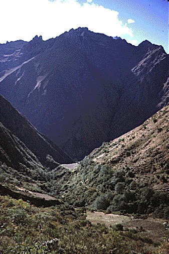
The trail begins to climb slowly through fairly dense sub-tropical vegetation. The trail was steep and kept to the south of the river. The trail winds steeply towards the first pass, cutting through dense vegetation until reaching an open meadow. Again, we kept passing small villages of six to ten homes every hour or so. The views started opening up and the area become much more alpine. Looking back in the direction of our first camp looked like this.
|
| Looking back from near Warmi Wa˝usa pass, with the Trail on the right side of the Valley |
We reached the Warmi Wa˝usa pass, the highest point of the Inca Trail at 4,050 m. (13,276 ft.) shortly after noon. The pass was quite cold and windy, with magnificent views in all directions. The pass had quite a few people waiting around there on the grass. We waited at the top for about a half hour, and then descended down the trail. We stopped about 30 minutes down the trail and had lunch.
We found out at lunch that not all in our group were having a good time getting over the pass. One guy from Arizona was moving very slow, with all the typical altitude symptoms. Another Brazilian guy was noticing his hands turning numb, and felt he couldn't get over the pass (he had stopped only 10 minutes from the top). We were told the only option for not going over the pass was heading back the way we came, and possibly getting a horseback ride back to the trailhead (a very long way). And even from the trailhead, you are a long way from anywhere!
From our lunch area, we could see the trail for the next day ahead of us, and it was a great view. We were going to camp at the base of the valley, along the Pacamayo River. We could see the trail all the way up to the next set of ruins, Runcurakay, which was very circular and high up the next mountain. At this point the trail was composed of thousands of stones.
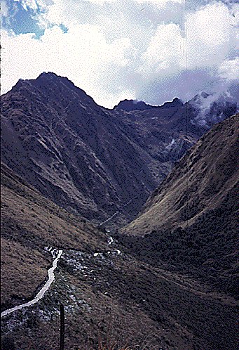 |
Views of the trail all the way to the second pass |
We were very glad when our altitude-sick friends reached us in about an hour. They had a late lunch, and we all descended down to the bottom of the valley to set up our camp. The area was very small with only a few sites for tents. There was a small Inca ruin there, with a working shower (unheated river water) and an outhouse with toilet seats.
We encountered a very heavy rainstorm between our afternoon tea time and dinner and we retreated into our tents. We were served our dinner in the tents by the porters, who were getting drenched carrying out their duties. I felt like a very pampered camper. It was another early night to sleep.